
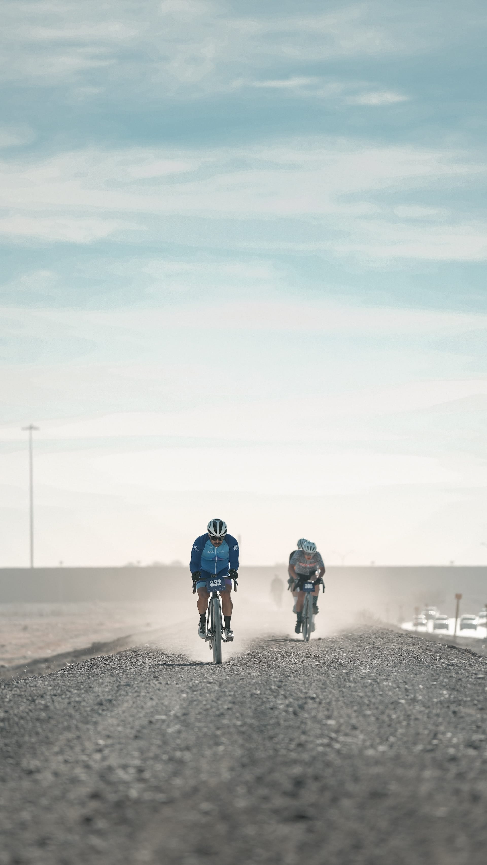
CIUDAD JUÁREZ, Mexico – After only a few miles, the group had settled into a rhythm. Five of us. No talking, but communication known among cyclists: taking pulls, shuffling front to back, silently figuring out who might still be there in 20 miles. We’d already picked up two riders from up the road, and dropped two more, and now this seemed to be it, the chasing group of five, as we sped along the crushed stone on the flat levee into a mild but steady headwind. My eyes focused on the wheel in front, occasional rocks and ruts kicking the bike a bit, but not too much.
It was, in other words, just the normal stuff of gravel racing, as it had been all that morning, when hundreds of riders gathered in the crisp early day beneath a big banner, alongside tents of local cycling clubs, music pumping as an announcer listed off, in Spanish, the start times for different categories in this year’s “La Candelaria,” a 34-mile race for gravel and mountain bikes beneath blue desert sky.
The start line was set in an office park on the southeast edge of this Mexican city separated by the Rio Grande from El Paso, Texas. The two cities, geographically, are really one, their sprawl filling a valley cut by the Rio Grande, hemmed by mountains on the north, in the United States, and to the west, in Mexico. The combined three million or so residents of Juárez and El Paso make it the second-largest binational metropolis in the western hemisphere, an interwoven community increasingly separated by a border defined from afar.
Just after 9AM on that February Sunday, and only a few hundred yards from the start, the racers turned onto the levee that traced the Rio Grande, and would follow the Mexican side of the fortified border 17 miles through the heart of the cities to their western edge, then back again. For the four others in the group around me – three from Mexico and a Dutch guy who had lived for years in El Paso and Juárez – the early miles seemed to be just about those moments of settling into the race, heads down, hearts pumping. Light industrial buildings and open lots flew past on the Mexican side, to our left, and the iron pilings of the border wall stood sentry over low residential neighborhoods, to our right.
Then, 10 miles in, the levee curved to the west and we entered further into a landscape defined by political division. I was sitting second wheel in the group, and just past the lead rider’s shoulder I saw the bright red beams of La Equis, a steel sculpture 20 stories tall that was built to celebrate the mix of Spanish and indigenous cultures in Mexico on a swath of land returned to Mexico from the United States in the 1960s.
The Rio Grande, which springs from headwaters in what is now northern New Mexico, became the border between the two nations in 1848, with a treaty at the close of the Mexican-American War. The river flowed freely back then, and a southward shift of its channel later in the 1800s had delivered hundreds of acres of Mexican land to the United States. That was disputed until it was returned to Mexico a century later. El Paso residents had to move out when it again became Mexican land, making way for the park, and eventually the sculpture.
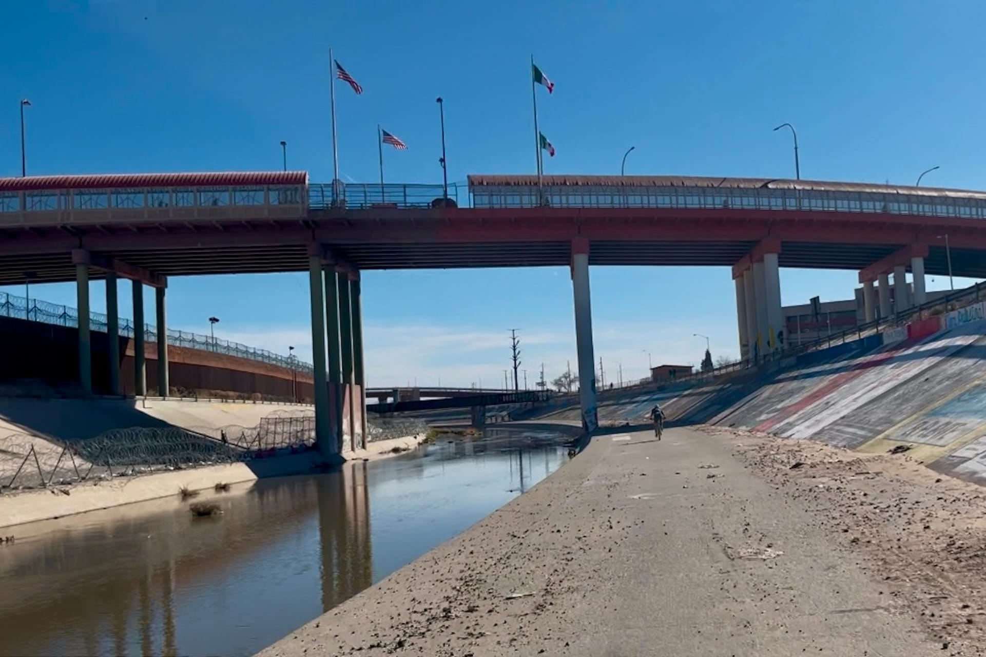
Bridges and walls: mixed messages at the Rio Grande. Photos © Tom Haines
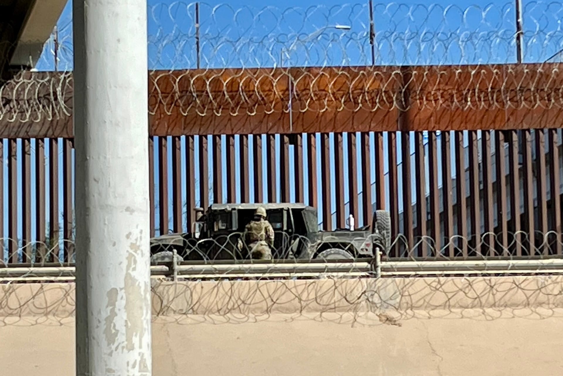
In the century since the Rio Grande shifted course, upstream irrigation dams have nearly drained it, and what narrow river passes between Ciudad Juárez and El Paso today flows between concrete banks. Vertical brown beams of the border wall on the U.S. side loom much larger than any natural elements of the landscape. Razor wire loops along the top of the steel beams, creating a prison effect in reverse, as the wire is meant to keep people out.
My only prior trips into Juárez had all come on foot, walking across a busy bridge at a border checkpoint in the city center to catch flights from the city’s airport deeper into Mexico. Three fast miles after we raced past the sculpture, I realized we would soon arrive at that bridge, the Paso del Norte, the most central of six border crossings between the two cities. The levee passed directly beneath the bridge, and as I looked up, I could sense the shadows of people walking northward to the United States, carrying a few possessions for the day.
The bridge, built in 1967, carries foot traffic north and south and non-commercial vehicles from Mexico into the United States. Sometimes there are scenes of chaos or contraband. Groups of migrants have crowded onto the bridge in search of asylum. Customs agents sometimes catch cars carrying hundreds of pounds of drugs.
But mostly, traffic on the bridge is legal: Mexicans with permission to travel north for work or study, or US citizens from El Paso and elsewhere who cross south each day to see family or friends, or to visit doctors, just as talented but far cheaper than those in the US healthcare system.
We rolled past the Michoacana shop at the base of the bridge that sells so many flavors of ice cream, and soon the crowded hillside neighborhoods of western Juárez came right to the edge of our route. Smooth gravel quickly gave way to deeper ruts and bigger rocks and, in a few spots, long sandy washes. Our group of five strung out, as we rode over a train track and picked our way past a busy traffic roundabout where an old school bus from the US, now painted a pattern of reds and browns, waited to shuttle commuters around the city. I felt for the first time an urge to stop, more interested in the human terrain all around me than the idea of racing.
The dirt lane dipped close to the river’s banks and rose again along a straight stretch with shacks and battered vehicles and the leaning branches of shade trees. Two boys strapped on inline skates next to a small park with paved lanes. A bigger group of kids gathered for soccer on a dirt field. At a particularly deep dip followed by a quick pitch up, I noticed that my left shoe had untied, and I tried while rolling to tuck the flailing lace into my sock. One of the guys in the group shouted in Spanish some friendly encouragement for me to keep going, as we’d be faster together. But I waved him on, put down a foot, and looked not straight ahead, but all around.
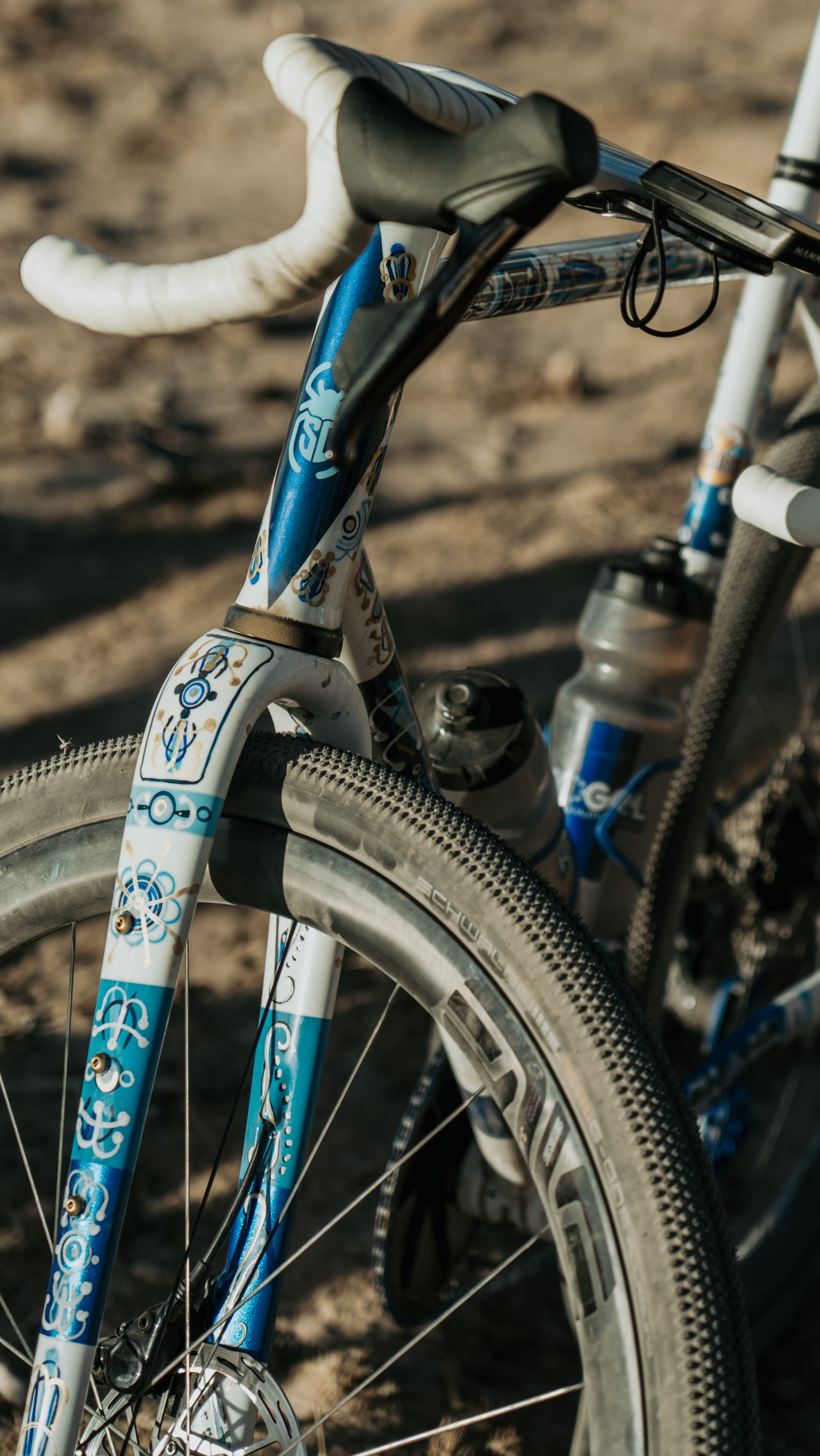
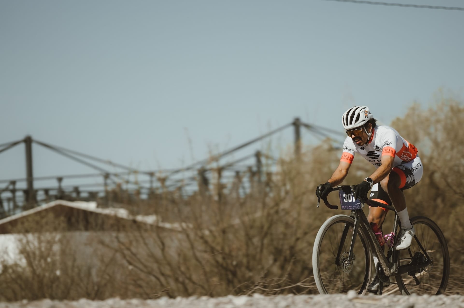
Juxtapositions were everywhere at Candelaria, on the course and even in the indigenous-inspired paint on this Scarab. Photos © @lente_de_shay
To the north, on the opposite side of the Rio Grande, and beyond the steel beams of the border wall, elevated lanes of Interstate 10 arced toward New Mexico, as though eager to avoid not only the border, but the dirt alleys of the poor neighborhoods just on the Mexican side. Beyond that interstate, even higher, on a hill, rose the campus of the University of Texas at El Paso. It had been designed to mimic the Himalayan architecture of Bhutan, and as mid-morning sun struck the crème-colored facades and red-tile roofs of dozens of buildings, the campus shimmered as a kingdom of opportunity just beyond reach.
Much closer to me, before that campus, and beneath that interstate, nearly lost amid the urban architecture and political divide, the narrow channel of the Rio Grande flowed flat, quiet. Thick tufts of dry grass stood on its banks. On the U.S. side, after just a few feet, the grass gave way to coils of razor wire stacked on the dirt bank. A US Border Patrol SUV idled nearby.
I rolled on, slower now, stopping to take photos and feel the winter day warming. The route neared the mountains at Juárez’s western edge, with the open desert of New Mexico just beyond. With US border enforcement focused so intensely on urban crossings, more determined migrants venture into that desert on foot, guided by cartels that charge heavily for their suspect service. Last year, more than 130 migrants died while trying to cross that desert expanse and elsewhere in the Border Patrol’s El Paso Sector, more than in any year before. And nearly 700 migrants died along the 2,000-mile length of the border in 2022, according to the UN’s International Organization for Migration, making the U.S.-Mexico border the deadliest land crossing in the world.
At the base of the first mountain, across from the site of a long-ago decommissioned copper and lead smelter on the U.S. side, the dirt track ended, marking the U-turn for the racecourse. The Casa de Adobe, a small dirt building preserved for its history as a brief headquarters during the Mexican Revolution, sat just to the left of the turn-around. A small crowd had gathered beneath two pop-up tents. Volunteers handed out cups of water and hunks of fresh fruit, cheering as racers turned around for the trip back along the border.
I gulped water and a bite of banana. The shallow river, just a few feet away, sparkled in a deep brown. For a moment, I nearly forgot where I was, as though the bank of the Rio Grande were just a nice place to ride a bike.
Did we do a good job with this story?