
NOTE: This ride has a narrow weather window in autumn; just days after my visit, a strong storm October 28-29 is likely to drop a foot of snow or more and shut down access until spring. As Denver Broncos fans like to say, there's always next year, so consider this a planning guide for 2024.
I’ll admit, I wasn’t expecting the snowdrifts.
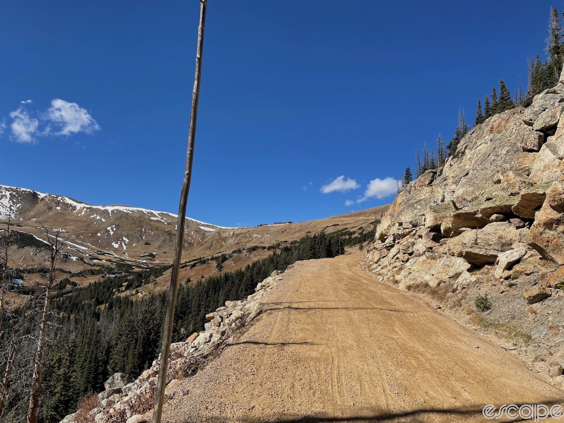
I’d just started riding again out of the visitor’s center atop Trail Ridge Road in Rocky Mountain National Park when I saw, on the road rising ahead of me, long stretches of snow clinging stubbornly to the pavement. Although they looked old – glacial, almost – with little sastrugi-like creases on the surface, these wind-packed, foot-deep drifts weren’t here mere weeks ago.
But high in Colorado’s Rocky Mountains in late October, winter comes in fast. And without anyone to plow them, the drifts stuck, even as the gray granite slopes all around were mostly scoured bare. I would have to walk.
The loop ride of Old Fall River Road, a dirt-road climb, and Trail Ridge, the highest paved pass in the United States at 12,183 feet (3,713 meters), is a bucket-list ride by any definition. While not especially long, it features between 4,000-5,400 feet of climbing depending on where you start and finish, and jaw-dropping views for almost every pedal stroke along the way.
As great as the ride is, it has one drawback, endemic to riding in most National Parks in the US: cars.
Old Fall River Road is one-way travel thanks to its steep and narrow nature. You’ll see cars, but they’re not moving fast and are generally easy to navigate around. The far larger problem is Trail Ridge. RMNP is the fifth-most visited National Park in the US. It sees almost a million visitors a month in high season, and Trail Ridge’s expansive vistas - accessible by motor vehicle just five months a year – are the main attraction. It’s hard to appreciate the views when you’re riding around that many cars: drivers in ponderous RVs or tow-behind trailers they’re inexperienced at handling on winding mountain roads; drivers distracted by the views; drivers distracted by trying to find one of the precious few parking spots, or get out of same.
But for a narrow window of time in late fall, all that changes: in early October, the Park Service closes Old Fall River Road to motor vehicle traffic; a couple of weeks later, it closes the gate on Trail Ridge at Many Parks Curve on the east side and the Colorado River Trailhead on the west side. But cyclists are still allowed until December 1, or until weather conditions shut it down (hikers are allowed even in winter). Which means for a few weeks a year, a bike grants you access to a most unusual VIP experience: to have one of America’s most popular natural wonders all to yourself.
You just might have to hike through a few snowdrifts for it.
The first part of the ride is easy. After paying my entry fee at the Fall River ranger station just west of Estes Park and climbing a sweeping right-hand bend, the hills fall away and open into a broad, flat valley and its most notable feature: an alluvial fan of jumbled boulders formed by a massive 1982 flood. But to the west looms a formidable rampart of tall peaks, ridgelines even now rimmed with white cornices, the remnants of last winter. That’s where I’m going.

Cars pass periodically, including one with a pair of gravel bikes on a hitch rack. “I’ll bet I know where they’re headed,” I think, and, sure enough, a mile later I spy them parked at a pullout area. “Hey, seems like you guys had the same idea I did,” I say by way of opening. I silently note their tires are considerably burlier than my 35mm Ritchey semi-slicks, and I glance up at the snow again. “How far are you going?”
“I think we’re planning to go up to the visitor’s center and then probably back down,” offers one. “How about you?” I tell them I’m doing the loop. “Let’s hope there’s not too much snow up there, or I may see you on the way back, unless you catch me anyway,” I say with a grin as I set off.
One of the markers of a great adventure ride is that you’re not entirely confident things will work out as planned. It’s that little bit of uncertainty, of spice, that makes it more interesting. But as bummed as I would be to not do the whole loop, I tell myself that the very least, Old Fall River/Trail Ridge is as easily bailable as a ride like this gets. It’s basically one long climb, and at any point that things get too hairy, you can retreat fairly quickly. At least, I hope so.

Not long after my encounter with the other cyclists, the flat part is over: the valley closes in, narrowing, and the hills loom over me. A driver passes, then slows before coming to a long stop in front of the closed gate. I can almost read his confused chagrin from outside the vehicle. As I ride past, through the gate, the road immediately turns to dirt, and tilts up just as abruptly, a steep, narrow ramp rising off the valley floor. After passing a few day hikers in the first half mile, I am entirely alone, and as Chasm Falls recedes behind me, the only sounds are the crunch of my tires on the dirt and my breath as I meter my pace up the initial pitches.
Every now and then, a whoosh fills the treetops: a gentle breeze at the ranger station, the wind here is steadily strengthening. Sheltered in the forest, I can’t feel its full effects yet. The road winds up through switchbacks and long meandering stretches as it climbs. Copses of aspens, leaves now dropped, intersperse with Douglas fir, spruce, and Ponderosa and Lodgepole pines. In places, I can see not only many dead snags, but stands of trees with rusty red needles. These are casualties of pine beetles, whose expanding range and damage are due to the same reason it’s late October and I’m climbing with no gloves and my jersey fully unzipped at 9,500 feet (2,900 m).

More switchbacks. The trees begin to thin, imperceptibly at first, but noticeable from the increasing exposure to the wind. Granite boulders peek out from underneath. To my left, the massive ridgeline of Sundance Mountain, on the opposite side of the valley, is striated with patches of snow on the shaded, north-facing slopes. It looks fresh. I round a corner and the far ridgeline heaves into view. A flat orange patch catches my attention: dust on snow? No, it’s the wall of the Trail Ridge visitor’s center, impossibly far away, impossibly higher above me than it should be after an hour of climbing.
In a final set of switchbacks, the forest stunts and suddenly falls away: treeline. The wind, so gentle and warm below, is now a constant, cold presence even in the bright sunlight. Nothing here grows more than a few feet tall; the growing season is too short, the winter winds too fierce. Cut pine poles, some 15-20 feet tall and weathered grey, stand along the roadside every few hundred feet. They mark the road for plows in the spring, their height a silent sentinel to the snows that will come. At this altitude, I’ve dropped maybe 10 percent from my normal power output. My breath comes sharp and ragged. The homestretch: one last steep pitch, a long, looping bend and straightaway, and I duck under the thin plastic tape across the roadway at the visitor’s center parking lot.

I find a sheltered spot in the lee of a building to snarf down half the raspberry scone I’ve hauled to the top as a prize. (I tend to favor real food on rides, but as tempting as the chipotle chicken empanada was when contemplating my choices the day before in the grocery store's prepared foods section, the scone seemed like a slightly safer choice.) The visitor's center and parking lot, usually buzzing with tourists and vehicles, is utterly deserted: not a single car. It’s been over an hour since I’ve seen another human – a pair of cyclists riding up and a trio of them heading down. The visitor's center is already winterized: windows boarded against the coming drifts, water shut off and bathrooms closed. The views back down the valley are mesmerizing, but I feel an urgency of sorts, not to linger too long in this high, inhospitable place.
That’s when I hit the snowdrifts.
Since I’ve done this ride once before, I know that the visitor’s center is not the summit; that comes a few miles later on the undulating rollers of Trail Ridge. But looking at the snow-covered road, I begin to wonder whether out-and-back on Fall River might prove the wise choice. My pace: pedaling 100 feet, then dismounting to hike across a drift, then bashing the snow out of my cleats to pedal another 100 feet, is arduously slow. I begin to do the math: from the visitor’s center, it’s probably three miles to the summit, then another couple of miles of descent before I'd be safely below the snow line. Up ahead, the road disappears around a bend to the left, where the sun angle may be more favorable than this northwest-facing aspect. I’ll keep going, I tell myself, and make the call based on what I see.

I crunch my way through the snow, then remount and gingerly pedal, cleats balanced precariously on pedals they won’t engage, as I tiptoe around the corner. I breathe an audible sigh of relief, if anyone were around to hear it. The road stretches away, slightly drifted in spots but rideable. I still can’t clip in my right pedal, so I stop and lay the bike down and remove my shoe. Nearby I hear the yips and chirrs of some very puzzled marmots and pika. The cleat is packed with snow, compacted and fused into a solid block of ice. I find a small rock on the side of the road and gradually chip it free. My glove is clenched in my teeth to keep it from blowing away, and I brace myself against the gusts, which are tropical-storm force strong. At least, I tell myself, it’ll be a cross-tail for most of the ridge.
Snowdrifts vanquished like I’m some Victorian-era mountaineer, cleats functional again, I inch my way to the ride’s high point. The scale of these mountains is almost literally unfathomable: spots that look like you can reach out and touch them are a 15-minute ride away, and at 12,000 feet, rollers hit a bit different. I resist the habitual temptation to focus on my front wheel as I crawl to the summit. It’s a clear blue day, and I can see for miles, from the nearby rugged scarp of the Continental Divide to the Gore Range far beyond. I’m on the roof of the world, and to be here alone feels both awesome and illicit, as if I’ve been granted some audience with the divine that I have not earned.

At the top, I pause to pull on a jacket and hat against the chill of the long descent to come. Pushing off, I rapidly pick up speed. At this altitude, the atmosphere is only 70% as dense as at sea level; with the scale of the landscape tricking your eye, it’s easy to find yourself doing 40 mph on what looks a not-particularly steep section. Normally, I’d be white-knuckling the bar in these gusty winds, trying to be mindful of every car around me. But today, I can ride any line I want; the road beckons, empty, smooth, and fast.
The road drops back below treeline and I see the first humans I’ve spotted in almost two hours: three cyclists riding up. The wind lessens and the air warms as I drop the snaking curves down to the valley below. A few final corners and I’m at the gate at Many Parks Curve, ready to re-emerge into civilization. Barely 15 minutes later, I’m across the alluvial fan again and back at the car in the lazy warmth of a late fall day.
I’m jarred by the juxtaposition, the abrupt transition from the lonely heights to the bustle and busyness of ordinary life down below. Just outside the park entrance, I passed an open-top Jeep from a commercial tour operator. These can be a fantastic way to see the park, especially for those who don’t want to drive in its often-hectic environs. There are private tours as well, for a higher fee. But the park doesn’t allow helicopters, and there are no skip-the-line tickets, VIP boxes, or exclusive-access packages for the 0.1 percent.
For these precious few weeks, the bike is the only way in. Riding one granted me – for as long as I wanted to stay – the experience of having an entire National Park to myself. What, I wonder, would people pay for that?
If you go
How long is the ride?
You can tailor the length of the ride based on where you start and finish; at this time of year all have plentiful parking. There are three basic options:
- 44 miles, 5,300 feet of climbing: start and finish in Estes Park (Safeway parking lot)
- 35 miles, 4,700 feet of climbing: start and finish at the Fall River visitor’s center (my route, in map below)
- 30 miles, 4,100 feet of climbing: start and finish at the Alluvial Fan parking area on Fall River Road

When should I go?
The Park Service typically closes Old Fall River Road to motor vehicle traffic in early October. The Trail Ridge closure typically happens around the middle of October and both are announced on the NPS web site. From that point, the roads are open to cyclists, hikers, and equestrians until December 1, when they revert to trail status (no bikes). Note that these are access dates. Actual ridable conditions depend entirely on the weather. A big early storm can dump significant snow above 11,000 feet, and it may not melt. The roads open again in mid to late May, conditions depending. As in autumn, they open first to non-motor vehicle traffic, which offers a short spring window to do this ride as well. That's a different experience, with walls of snow lining the road and much sloppier conditions (install fenders), but it's equally rewarding. More park info here, and you can check the Trail Ridge visitor's center web cam for a real-time look at conditions.
What’s the cost to get in?
Day passes are $15 per bike, $30 per car.
In high season RMNP requires a timed entry pass for motor vehicles, reserved in advance. That system usually ends around the third week of October, but dates vary by year, so check the web site for details. Bicycles do not need a timed entry pass at any time of year.
What’s up in Estes Park?
The gateway to Rocky Mountain National Park? Glad you asked. It’s a lovely little town, set in a gorgeous location. If you have time, do linger here a bit. Good places for a post-ride refuel include Ed’s Cantina (Mexican), Smokin’ Dave’s BBQ, and Claire’s (American), to name three. Want something a little more refined? Try Seasoned. Just need coffee and a pastry or sandwich? Kind Coffee is your jam. If you want to make an overnighter out of it, Estes is packed with good hotels at various prices, and we’d be remiss if we didn’t mention the Stanley, aka the hotel from "The Shining." Nice place, only maybe haunted, and the elevators don't even gush blood.
What kind of bike should I ride?
An all-road or gravel bike is the sweet spot. E-bikes are allowed. Your gearing needs depend on your fitness and experience, but Old Fall River climbs over 3,000 feet in nine miles, on dirt, and it starts at 8,100 feet high. There's almost 1,000 feet more climbing in a few miles of Trail Ridge, all of that above 11,000 feet. I recommend a 1:1 low gear. As for tires, you won’t need aggressive tread on Old Fall River's improved dirt surface unless it's dusted with snow, and big meaty tires will slow you down on Trail Ridge, which is smooth, well-maintained pavement. Semi-slicks between 30-40 mm are a good balance of enough cushion and traction, with low weight and rolling resistance.
How much food and water do I need?
There’s no place to re-supply once inside the park, so bring enough for a three-hour ride, or a little more to be safe.
What about kit?
Between personal preference and variable weather, it’s hard to recommend a specific system. This one’s all about layers, including a shell for protection up top. Add some warm gloves, a thermal hat, good socks and booties or toe covers, and a neck gaiter. Between jersey pockets and a small handlebar bag, I had plenty of capacity. Don't skimp on the gear; October in the Rockies can be gorgeous and 55°F/13°C like the day I did it, or it can be a raging snowstorm. I recommend doing this ride only on days with stable, clear weather forecasts. Take into account that temperature drops about 3°F for every 1,000 feet of elevation, and wind chills will make it feel colder still. And don't forget the sunscreen.

What else should I know?
There’s almost no cell coverage up here. Let me repeat that: your phone won’t fucking work. Tell people where you’re going but don’t rely on real-time route sharing from your head unit as this relies on cell signals; Wahoo’s Livetrack feature cut off shortly after I started and then told my wife – half an hour after I finished – that I rode 1.3 miles with 7,200 feet of climbing. You will not be able to call 911.
Check multiple weather forecasts, especially the National Weather Service point forecast for Trail Ridge. Most commercial weather forecasters are focused on population centers, where people have the ability to easily find shelter in severe weather. Those forecasts don’t reflect conditions at altitude, and weather here can be vastly different than even a few miles away if there’s a major different in elevation like, say, between Trail Ridge and Estes Park. There is no shelter on Trail Ridge after the crews have winterized all the buildings. Weather can come in fast and hard. Keep an eye on conditions, and don’t be afraid to turn around.
I cannot stress this enough: bring a waterproof jacket. Actual waterproof, not just a DWR windshell. Forecast calls for showers? Waterproof jacket. Cloudy and cool? Waterproof jacket? Sunny and bluebird? Waterproof jacket.
Remember the 80 percent rule. A long time ago, I used to regularly attend product launch events, at which some (invariably young, invariably male) cycling journalist invariably got hurt trying to impress everyone with how rad he was. Thus, the 80 percent rule: when on an unfamiliar bike and/or on unfamiliar terrain, stay within 80 percent of your skill limits. That certainly goes for Trail Ridge after the motor vehicle closure. If you get hurt up here, you are exposed, at altitude, with no immediate help outside your riding group, and no way to call for assistance.
Keep an eye on your own and your companions’ condition. Headache, dizziness, and nausea are signs of altitude illness, or Acute Mountain Sickness. AMS is a nasty hit; it’ll take all the energy right out of you. If you can’t generate power anymore, or your heart rate skyrockets when you try, just turn around. It is extremely unlikely that you would develop more severe forms of altitude illness in such a short amount of time, but if anyone in your party worsens, especially with a constant, dry cough or a bluish tint to skin around the lips or fingers (cyanosis), head down immediately and seek medical treatment.
Did we do a good job with this story?